
Cearn Solar Farm's first formal filing: up to 180 lorry movements a day at peak and two to four years of building from mid-2029, on farmland near Lyford.
The company behind Cearn Solar Farm, the 2,800-acre scheme proposed for farmland north of Wantage, has filed its first formal document with the Planning Inspectorate. It estimates up to 180 heavy goods vehicle movements a day at the peak of construction, and two to four years of building from mid-2029 at the earliest.
The EIA Scoping Report went to the Secretary of State on Monday 26 October. It sets out what the environmental assessment will cover, and it is the most detailed description of the scheme published so far.
The filing lands days after Vale of White Horse District Council passed a motion on Cearn. The council’s leader will write to ministers about the scheme’s size, its use of farmland and its overlap with the White Horse Reservoir.
Where it is
The solar panels would sit in three main areas south of Garford, east of Charney Bassett, north of West Hanney, south of Goosey and north-east of Baulking, according to the developer’s project website. The scoping report puts the centre of the panel area at grid reference SU375932. That is about eight miles west of Abingdon and three and a half miles north of Wantage.
Underground cables would run about 12km north-east to National Grid’s proposed substation at Farmoor. The developer, Cearn Solar Farm Ltd, is a subsidiary of Telis Energy UK. It says the scheme has a grid connection offer of up to 500MW, which it puts at the equivalent of up to 143,000 homes.
In a written question to the leader for the 21 October council meeting, Councillor Jill Rayner said the plans show the solar farm “completely surrounding” the village of Lyford.
What the scoping report says
The report describes the scheme’s working assumptions. All of them can still change as the design develops.
- Land: about 1,691 hectares in total, including the cable corridors. The panel areas alone are the roughly 2,800 acres (1,133 hectares) the developer has quoted since September.
- Panel height: up to 3.5 metres, and up to 4.5 metres where panels must sit above flood water.
- Battery storage: an on-site battery energy storage system, with units up to 3.5 metres tall, plus an on-site substation with parts up to 15 metres high.
- Construction: mid-2029 at the earliest, lasting an estimated 26 to 48 months, and only if both the solar farm and the Farmoor substation are approved. Power would flow from 2031 at the earliest.
- Lorries: up to 180 HGV movements a day at peak, an “indicative” figure that excludes workers’ vehicles. Three to five abnormal loads would bring the largest substation parts.
- Access: not decided. The report says it is “likely to be taken from the A338”, using local roads, a new internal haul road, or both.
- Lifespan: about 40 years, then 12 to 24 months of decommissioning.
The farmland question
This is where the council’s concern and the developer’s own figures meet.
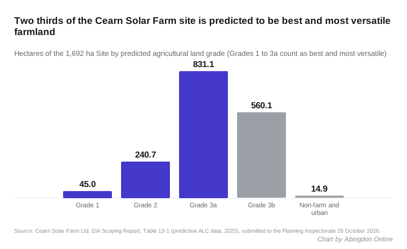
The scoping report’s Table 13-1 uses predictive mapping, not a field survey, to grade the land. On that basis about two thirds of the whole site is “best and most versatile” agricultural land, the top three grades that national policy asks developers to avoid where they can:
| Land grade | Hectares | Share of site |
|---|---|---|
| Grade 1 (excellent) | 44.96 | 2.7% |
| Grade 2 (very good) | 240.73 | 14.2% |
| Grade 3a (good) | 831.10 | 49.1% |
| Grade 3b (moderate) | 560.05 | 33.1% |
| Non-agricultural and urban | 14.90 | 0.9% |
For the panel areas alone, the report puts the best and most versatile share at 75%. The report says a detailed soil survey of the panel areas will follow.
The developer says the land would stay in partial farm use. Its information booklet says the design allows sheep grazing between the panels.
What the council decided
At full council on 21 October, Councillor Lee Evans proposed a motion on Cearn. It passed “with some amendments”, the council said in a statement on 23 October. The minutes, which will give the final wording, are not yet published.
The original motion asks the leader, Councillor Bethia Thomas, to write to:
- the Secretary of State for Environment, Food and Rural Affairs, about the size of the scheme and the loss of farmland
- Oxfordshire County Council’s Cabinet Member for Transport, about construction traffic on top of the reservoir’s
It also asks the Cabinet to draw up a renewable energy policy for the Vale. A published amendment from the Green group would add a push for community benefits and biodiversity gains, and a reference to the combined effect of Cearn, Botley West and the reservoir.
“If they’re wholly decided in London, the impact on local people can’t be properly taken into consideration,” Councillor Thomas said in the statement.
The decision will not be the council’s. Any scheme over 100MW is a nationally significant infrastructure project, so the Secretary of State for Energy Security and Net Zero decides, after an examination by the Planning Inspectorate. The council is a statutory consultee.
The overlap with the reservoir
Councillor Thomas said construction of Cearn and the reservoir “could overlap”. A councillor’s motion on the 21 October agenda, later withdrawn, said Thames Water intends to submit the White Horse Reservoir application in late November 2026. We reported in September that its traffic peak now falls in 2030, the year after Cearn’s earliest start.
The developer’s booklet says it is “in regular dialogue with Thames Water” to manage the overlap between the two projects.
What it means for you
- You cannot comment formally yet. The first stage, “Co:Design” workshops in September and October, was closed to the public; parish councils and elected members represented residents, the booklet says.
- The public consultation is due in February and March 2027. That is stage two in the developer’s programme document. It will show the cable route and the site masterplan. You can register for updates on the project website.
- The developer does not have to consult you. Its own booklet notes that the Planning and Infrastructure Act 2025 removed the legal duty to consult the public before applying. It says it will consult anyway.
- The application is due around September 2027. If the Planning Inspectorate accepts it, anyone can register as an interested party and take part in the examination. Follow the project page to be told when that opens.
- If you live near the A338 between Wantage and the A420, watch the access plans. The report names the A338 as the likely route in for construction traffic.
Have your say